
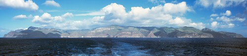
 Saint Helena is one of the world's best kept secrets. Located in the South
Atlantic Ocean (15.95°S, 5.70°W; map), St. Helena is a
small (122 sq. km; 47 sq. mi.) island (topographic map)
and is extremely remote (1200 miles from the west coast of Africa, 1800 miles from Brazil) and
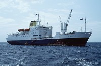
difficult of access, being served only by the Royal Mail Ship (RMS) St.
Helena.
Saint Helena is one of the world's best kept secrets. Located in the South
Atlantic Ocean (15.95°S, 5.70°W; map), St. Helena is a
small (122 sq. km; 47 sq. mi.) island (topographic map)
and is extremely remote (1200 miles from the west coast of Africa, 1800 miles from Brazil) and
difficult of access, being served only by the Royal Mail Ship (RMS) St.
Helena.
Although most noted as the place of final exile and death of Napoleon, St. Helena has much more to offer with its long and fascinating history and spectacular natural history.
- 21 May 2002 was the Quincentenary of the discovery of St. Helena:
The new museum in Jamestown opened ...
the St. Helena National Trust was launched, and ...
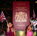
Saints rightly had full British citizenship restored.
Present day St. Helena
 St. Helena is a British Overseas Territory and one of the last relics of the
colonies. The island has a Governor and the upper echelons of the administration
mostly are expatriate British. The islanders are represented by an elected Executive
Council (EXCO) and Legislative Council (LEGCO) although these bodies have little
real influence on the running of the island.
St. Helena is a British Overseas Territory and one of the last relics of the
colonies. The island has a Governor and the upper echelons of the administration
mostly are expatriate British. The islanders are represented by an elected Executive
Council (EXCO) and Legislative Council (LEGCO) although these bodies have little
real influence on the running of the island.
The population of St. Helena is approximately 6,000. The main centres of population are Jamestown (the capital), Half Tree Hollow, and Longwood. Ascension Island and the Falklands provide employment for a large number of Saints. There is a large Saint population in the UK and a substantial St. Helenian community settled in South Africa. Saints are extremely hospitable and visitors to the island are made to feel very welcome.
St. Helena's main income is from the export of fish. St. Helena coffee is of very high quality but the production is quite small. Tourism operates on only a very limited scale. Imports are high and the island has a large budget deficit; St. Helena receives a substantial annual grant-in-aid from the UK, most of which is budget aid although a significant portion is a shipping subsidy for the operation of the RMS.
The climate of St. Helena is strongly influenced by the southeast trade winds. The coastal areas are drier and hotter than the interior; in Jamestown the temperature ranges from 14°C to 32°C with an average annual rainfall of 152 mm (6 in.) whereas in the central hills the temperature ranges from 8°C to 26°C and the average annual rainfall is as much as 1 m (40 in.).
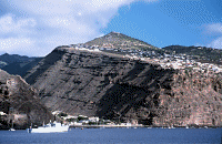
St. Helena has some stunning scenery. The coastline of the island comprises high vertical cliffs cut by steep-sided v-shaped valleys. The coastal areas are rugged and barren whereas the higher elevations in the centre of the island have lush vegetation. A good network of (albeit narrow, winding, and steep) roads makes much of the island reasonably accessible. However, the best of St. Helena is seen on foot; there are some magnificent walks and hikes to be had on the island.
The islands of Ascension and Tristan da Cunha are dependencies of St. Helena. Ironically, St. Helena's two dependencies are financially self-supporting.
 Take a photo tour of Saint Helena.
Interested enough to seriously consider physically visiting St. Helena?
Here's information on how to get there.
- St. Helena roots? The Archives
have records dating back to 1673; contact the Archivist
for information on researching the records.
- Want literature, maps, etc., for the South Atlantic islands? Try Miles
Apart.
- Ascension, St. Helena, and Tristan Web and EMail Directory.
- Links to other St. Helena, Ascension, and Tristan pages.
You are visitor number since 26 March 1999.
Over 9000 visitors from October 1997 to March 1999
Free counter provided by Honesty.com.
Except where otherwise noted, photographic images and text on this web site are copyright of Barry Weaver. You are welcome to download images and text, but if you use them or pass them on please acknowledge the source.
Comments? Corrections? More information? Contact:
Barry Weaver, Geology & Geophysics, University of Oklahoma bweaver@ou.edu
Page maintained by Barry Weaver
Last updated:
15 December, 2011